Home>Gift Ideas>Review: Best GPS Device for Hiking
Gift Ideas
Review: Best GPS Device for Hiking
Published: February 19, 2024
Discover the best GPS device for hiking with our comprehensive review. Find the perfect GPS device for your outdoor adventures and never get lost again.
(Many of the links in this article redirect to a specific reviewed product. Your purchase of these products through affiliate links helps to generate commission for Giftslessordinary.com, at no extra cost. Learn more)
If you love hiking, you know that having the right GPS device can make a huge difference in your outdoor adventures. In this review, we will take a look at the best GPS device for hiking. Whether you're a beginner or an experienced hiker, having a reliable GPS device can help you navigate through trails and keep you on track. Read on to find out which GPS device is the best for your hiking needs.

Overall Score: 8/10
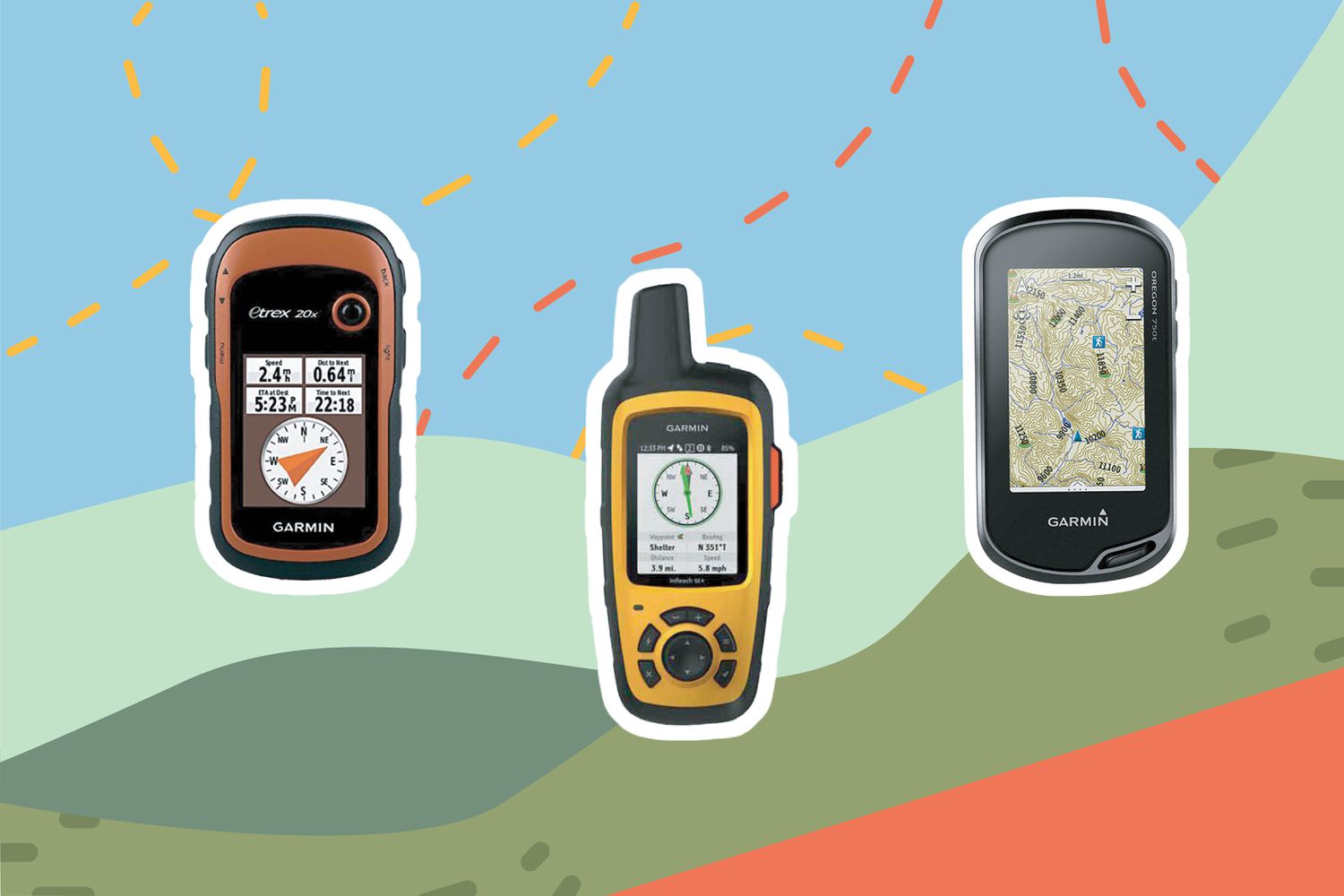
The Garmin eTrex 22x is a rugged handheld GPS navigator designed for outdoor use. It features a sunlight-readable color display, preloaded TopoActive maps, and support for GPS and GLONASS satellite systems. With 8GB of internal memory and a micro SD card slot, this GPS offers reliable navigation in challenging environments. The device runs on 2 AA batteries with a battery life of up to 25 hours. It is easy to use and suitable for activities such as hiking, geocaching, and bike tours. Despite some limitations, such as a small screen and the need for a separate program to delete geocaches, the eTrex 22x provides accurate and inexpensive navigation for outdoor enthusiasts.
Key Features
- Reliable handheld GPS navigator
- Sunlight-readable color display
- Preloaded with Topo Active maps
- Supports GPS and GLONASS satellite systems
- 8 GB internal memory, micro SD card slot
Specifications
- Color: Black/Navy
- Dimension: 4.00Lx2.10Wx1.30H
- Size: One Size
Pros
- Reliable basic GPS
- Easy to use and heavy duty
- Suitable for hiking, geocaching, bike tours
- Long battery life
Cons
- Small screen
- Separate program needed to delete geocaches
The Garmin eTrex 22x is a solid choice for outdoor navigation with its reliable performance, long battery life, and easy-to-use design. While it may have some limitations in screen size and functionality, it offers excellent value for outdoor enthusiasts looking for a rugged and dependable handheld GPS navigator.

Overall Score: 6/10
The Bushnell BackTrack Mini GPS is a portable, waterproof GPS device designed for hikers, hunters, and backpackers. It uses GPS technology to capture waypoints and allows you to guide back to your starting position. With an easy-to-read display, large glove-friendly buttons, and 35-hour battery life, the BackTrack Mini is a rugged and reliable tool for outdoor adventures. It also features Bluetooth connectivity for sharing trips and waypoints via the Bushnell Connect app. However, some users have reported issues with screen size, setup, and button responsiveness. Overall, the Bushnell BackTrack Mini GPS is a convenient and cost-effective option for simple navigation needs.
Key Features
- Rugged and waterproof design
- Easy to read display and large buttons
- Bluetooth connectivity for sharing trips
- Elevation, sunrise, and moonrise data
- 35-hour battery life
Specifications
- Color: Black and Orange
- Dimension: 3.00Lx2.00Wx1.00H
- Size: One Size
Pros
- Rugged and waterproof design
- Long 35-hour battery life
- Bluetooth connectivity for trip sharing
Cons
- Issues with screen size and readability
- Difficult setup and button responsiveness
The Bushnell BackTrack Mini GPS provides a convenient, cost-effective option for outdoor navigation needs, with a rugged waterproof design, long battery life, and Bluetooth connectivity for trip sharing. However, users have reported issues with screen size, setup, and button responsiveness, which may impact its usability in certain situations.

Overall Score: 8/10
The Healvaluefit Backpack Tether is a handy accessory for Garmin handheld GPS devices. It provides a hands-free mount for hiking and climbing, keeping your device safe and secure while on the move. The tether is compatible with various Garmin devices and features adjustable and stable design with a non-slip pad. The spring lanyard ensures the safety of your device by preventing accidental drops. The tether has received positive reviews for its usefulness and upgrade from the basic clip that comes with the device. However, some users have expressed concerns about the clip's durability. Overall, it is a great solution for carrying your GPS device while hiking.
Key Features
- Compatibility: Compatible with various Garmin devices
- Hands Free: Provides hands-free option for hiking and climbing
- Adjustable: Velcro can be adjusted according to the width of the backpack strap
- Stable & Non-slip: Non-slip pad design for stability on backpack straps
- Spring Lanyard for Device Safety: Ensures safety by preventing accidental drops
Specifications
- Color: Black
Pros
- Hands-free design
- Secure and stable
- Useful upgrade from basic clip
Cons
- Concerns about clip durability
The Healvaluefit Backpack Tether is a reliable and convenient accessory for Garmin handheld GPS devices, offering a hands-free and secure mount for hiking and climbing. While there are minor concerns about the clip’s durability, the overall usefulness and safety features make it a worthwhile investment for outdoor enthusiasts.

Overall Score: 7/10
The Garmin eTrex 32x is a reliable handheld GPS navigator preloaded with Topo Active maps, designed for outdoor activities such as hiking and cycling. It features a 2.2” sunlight-readable color display, support for GPS and GLONASS satellite systems, and 8 GB of internal memory for map downloads. The eTrex 32x also includes a 3-axis compass and barometric altimeter, all in a compact, waterproof design. Its battery life of up to 25 hours in GPS mode makes it ideal for long outdoor expeditions.
Key Features
- Explore confidently with reliable handheld GPS
- 2.2” sunlight-readable color display
- Preloaded with Topo Active maps
- Support for GPS and GLONASS satellite systems
- 8 GB internal memory and micro SD card slot
Specifications
- Color: Brown
- Dimension: 4.00Lx2.10Wx1.30H
Pros
- Compact and lightweight
- Accurate for geocaching and hiking
- Long battery life
Cons
- Small screen for some users
- User interface may be challenging for beginners
- Issues with software and updating
The Garmin eTrex 32x GPS navigator offers reliable performance for outdoor enthusiasts. While it may have a learning curve for some users, its accurate navigation, long battery life, and compact design make it a valuable tool for hiking and geocaching adventures. Despite some software and hardware issues, the eTrex 32x provides essential features for outdoor exploration.

Overall Score: 8/10
The Garmin 010-02258-10 GPSMAP 64sx is a rugged, water-resistant handheld GPS with a 2.6-inch color display. It comes preloaded with TopoActive maps, featuring routable roads and trails for cycling and hiking. With a high-sensitivity receiver, quad helix antenna, multi-GNSS support, 3-axis compass, and barometric altimeter, this GPS provides accurate positioning and tracking. It also offers wireless connectivity via BLUETOOTH and ANT+ technology. With a battery life of up to 16 hours in GPS mode, it's ideal for outdoor adventures.
Key Features
- Rugged and water-resistant design with button operation and a 2.6” sunlight-readable color display
- Preloaded with Topo Active maps featuring routable roads and trails for cycling and hiking
- High-sensitivity receiver with quad helix antenna and multi-GNSS support
- 3-axis compass and barometric altimeter
- Wireless BLUETOOTH and ANT+ technology
- Battery life: up to 16 hours in GPS mode
Specifications
- Color: Black/Tan
- Dimension: 6.30Lx2.40Wx1.40H
- Size: One Size
Pros
- Accurate positioning and tracking
- Preloaded Topo Active maps
- Wireless connectivity
- Rugged and water-resistant design
- Long battery life
Cons
- Battery consumption with continuous use
- Requires additional memory for updates
- Minor issues with connectivity
The Garmin 010-02258-10 GPSMAP 64sx is a reliable and versatile handheld GPS designed for outdoor enthusiasts. With its rugged design, preloaded maps, and various features, it’s a great companion for hiking, cycling, hunting, and other outdoor activities. Despite some minor drawbacks, its functionality and performance make it a valuable tool for navigation and exploration.

Overall Score: 8/10
The Garmin eTrex SE GPS Handheld Navigator is a simple-to-use GPS handheld that is perfect for hiking and geocaching. It comes with extra battery life, wireless Bluetooth connectivity, multi-GNSS support, and a high-resolution 2.2” sunlight readable screen. The device also offers access to multiple global navigation satellite systems for accurate tracking in challenging environments. The Garmin Explore app allows for wireless software updates, trip planning, and real-time forecast information. With long battery life, this GPS handheld is a reliable companion for outdoor adventures.
Key Features
- Simple-to-use GPS handheld with extra battery life
- Wireless Bluetooth connectivity and multi-GNSS support
- Sunlight readable screen with high resolution
- Access to multiple global navigation satellite systems
- Garmin Explore app compatibility for wireless updates and trip planning
Specifications
- Dimension: 2.40Lx4.00Wx1.30H
Pros
- Extra battery life for long usage
- Wireless connectivity and cloud storage
- Accurate tracking in challenging environments
- Real-time forecast information
Cons
- Intermittent restarting when paired with Bluetooth
The Garmin eTrex SE GPS Handheld Navigator is a reliable and user-friendly device for outdoor enthusiasts. With its long battery life, wireless connectivity, and access to multiple navigation satellite systems, it provides accurate tracking and real-time information. While there may be occasional issues when paired with Bluetooth, its overall performance and features make it a great companion for hiking and geocaching adventures.

Overall Score: 8/10
The Garmin InReach Mini is a small, rugged, and lightweight satellite communicator that enables two-way text messaging using the global Iridium network. It features the ability to trigger an interactive SOS, access downloadable maps, and optional inReach weather forecast service. This device provides peace of mind for outdoor adventures, allowing users to stay in touch with emergency services and loved ones almost anywhere in the world.
Key Features
- Small, rugged, lightweight satellite communicator
- Enables 2-way text messaging using global Iridium network
- Trigger an interactive SOS to search and rescue monitoring center
- Accessible downloadable maps and U.S. NOAA charts
- Optional in Reach weather forecast service
- Send and receive in Reach messages through compatible Garmin devices
Specifications
- Color: Orange
- Dimension: 2.00Lx1.03Wx4.00H
- Size: 1.27 inches
Pros
- Rugged, lightweight, small, and functional
- Extended battery life
- Optional weather forecast service
- Ability to define and send preset messages
Cons
- Somewhat expensive initial investment
- Messaging process can be slow
- App not always reflective of map updates
The Garmin InReach Mini is a reliable, compact, and functional satellite communicator that provides peace of mind and emergency communication capabilities during outdoor activities. While it may have some initial costs and minor inconveniences, the overall performance and quality make it a worthwhile investment for adventurers and outdoor enthusiasts.

Overall Score: 8/10
The ZOLEO Satellite Communicator is a rugged two-way global SMS text messenger & email device that ensures you stay connected in areas without cell coverage. It works with a free app on your smartphone and offers monthly subscription plans starting at $20. Features include global messaging, dedicated SMS phone number & email address, emergency alerting & medical assistance, and check-in & location sharing. The device is 3.58 x 2.60 x 1.06 inches in size, and available in black color. While it has some setup and app usability issues, it is a reliable and affordable option for staying connected in remote locations.
Key Features
- Global two-way satellite communicator
- Global messaging over lowest cost network
- Dedicated SMS phone number & email address
- Emergency alerting & medical assistance
- Check-in & location sharing
Specifications
- Color: Black
- Dimension: 3.58Lx2.60Wx1.06H
Pros
- Affordable monthly subscription plans
- Reliable in remote areas
- Long-lasting battery life
- Emergency SOS feature
- Automatic location sharing
Cons
- App usability could be improved
- Setup process is confusing
- Limited to text-only communication
The ZOLEO Satellite Communicator is a reliable and affordable solution for staying connected in remote areas. While it has some minor issues with app usability and setup process, its features like automatic location sharing and emergency SOS make it a valuable companion for outdoor adventures or solo travel.

Overall Score: 7/10
The Garmin eTrex® SE GPS Handheld Navigator is designed for easy navigation in any environment. It features a high-resolution display that is easy to read in bright sunlight and comes with a long battery life of up to 168 hours in standard mode. The product offers wireless connectivity with the Garmin Explore app on compatible smartphones for trip planning, weather updates, notifications, and mapping. With multi-GNSS support, a digital compass, and a water-resistant design, it is a convenient and reliable handheld GPS navigator for hiking, geocaching, and other outdoor activities.
Key Features
- The 2.2” high-resolution display: Easy to read in bright sunlight
- Long battery life: Up to 168 hours in standard mode and up to 1,800 hours in expedition mode
- Wireless connectivity with Garmin Explore app: For trip planning, weather updates, and notifications
- Multi-GNSS support including GPS, GLONASS, Galileo, Bei Dou, and QZSS: For tracking in challenging environments
- Digital compass and water-resistant design: Ideal for hiking in any weather
Specifications
- Color: Black/Yellow
- Dimension: 4.80Lx5.24Wx2.13H
- Size: One Size
Pros
- High-resolution display
- Long battery life
- Wireless connectivity
- Multi-GNSS support
- Digital compass
- Water-resistant design
Cons
- Clunky user interface
- Compass accuracy issues for some users
The Garmin eTrex® SE GPS Handheld Navigator offers a great combination of usability, reliability, and features for outdoor enthusiasts. With its wireless connectivity, long battery life, and multi-GNSS support, it is a valuable companion for hiking, geocaching, and other outdoor activities. However, some users may find the user interface and compass accuracy to be potential areas for improvement.

Overall Score: 8/10
The Garmin GPSMAP 66i is a high-tech GPS handheld and satellite communicator featuring TopoActive mapping and inReach technology. It has a large 3-inch sunlight-readable color display, supports multiple navigation systems, and comes with a preloaded Garmin TOPO map with Birdseye satellite imagery. This device offers two-way messaging and interactive SOS via the global Iridium satellite network, along with active weather forecasts and geocaching live. With a rechargeable lithium battery providing up to 35 hours of battery life, it's a reliable companion for outdoor adventures. However, some users have reported issues with the user interface and software, while others have praised its accuracy and reliability.
Key Features
- Large 3 inch sunlight-readable color display
- Interactive SOS and two-way messaging via satellite network
- Preloaded Garmin TOPO mapping with Birdseye satellite imagery
- Cellular connectivity for active weather forecasts and geocaching
- Compatible with the Garmin explore website and app
- Rechargeable lithium battery with up to 35 hours of life
- Supports multiple global navigation satellite systems
Specifications
- Color: Multi
- Dimension: 6.40Lx2.60Wx1.40H
- Size: One Size
Pros
- Accurate GPS and satellite communication
- Large, easy-to-read display
- Rechargeable battery with long life
- Compatible with Garmin explore app
- Cellular connectivity for weather forecasts
Cons
- Issues with user interface and software
- Expensive payment plans for maps
The Garmin GPSMAP 66i offers a wide range of advanced features for outdoor activities, including GPS navigation, two-way satellite messaging, and interactive SOS. Despite some reported issues with the user interface and software, its accuracy, reliability, and compatibility with the Garmin explore app make it a valuable companion for outdoor enthusiasts.
Important Features to Consider When Buying a GPS Device for Hiking
1. Battery Life
- Look for a GPS device with long battery life to ensure it lasts for your entire hiking trip.
- Consider whether the device uses disposable batteries or a rechargeable battery pack.
2. Durability
- Choose a GPS device that is durable and can withstand outdoor conditions such as rain, dust, and rough terrain.
- Look for devices with a high rating for water and shock resistance.
3. Accuracy
- Ensure the GPS device has high accuracy to accurately track your location and provide reliable navigation.
- Look for features such as WAAS (Wide Area Augmentation System) and GLONASS (Global Navigation Satellite System) support for improved accuracy.
4. Mapping and Navigation
- Consider the mapping and navigation features offered by the GPS device, such as preloaded maps, ability to download additional maps, and turn-by-turn navigation.
- Look for features such as a compass, altimeter, and barometer for enhanced navigation capabilities.
5. Size and Weight
- Choose a GPS device that is lightweight and compact for easy carrying while hiking.
- Consider the size of the screen and whether it is easy to read in various lighting conditions.
6. User Interface
- Look for a GPS device with a user-friendly interface that is easy to navigate and understand.
- Consider whether the device offers touchscreen or button operation, and whether it is intuitive to use.
7. Connectivity
- Consider whether the GPS device offers connectivity features such as Bluetooth and Wi-Fi for sharing data and connecting with other devices.
8. Geocaching and Waypoints
- If you are interested in geocaching, look for a GPS device that supports geocaching activities and allows you to input and navigate to waypoints.
9. SOS and Emergency Features
- Consider whether the GPS device offers emergency features such as a built-in SOS button, tracking capabilities, and the ability to send and receive messages.
10. Additional Features
- Look for additional features that may be important to you, such as a built-in camera, weather forecasting, and compatibility with other outdoor accessories.
Remember, the best GPS device for hiking will depend on your specific needs and preferences, so take the time to research and compare different models before making a decision. Happy hiking!
Frequently Asked Questions about Review: Best GPS Device for Hiking
A GPS device for hiking typically includes features such as a built-in map, GPS tracking, long battery life, rugged design, and a water-resistant exterior.
A GPS device can help you while hiking by providing accurate location information, guiding you along the trail, and helping you navigate through difficult terrain.
Yes, many GPS devices for hiking rely on satellite signals, so they can work in remote areas with no cell service.
Absolutely! Many GPS devices for hiking are designed to be user-friendly and easy to navigate, even for those who may not be very comfortable with technology.
Yes, there are various types of GPS devices for hiking, including handheld devices, smartwatches, and smartphone apps with GPS capabilities. Each type has its own unique features and benefits for hikers.